

57 Margaret's Place
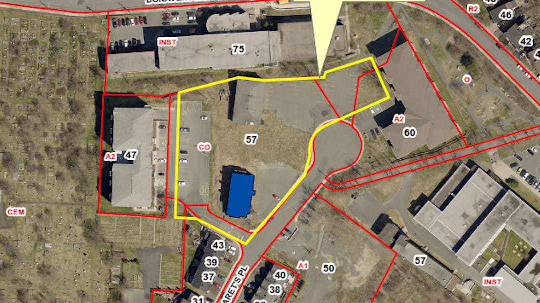
Stonemount Enterprises Limited has requested the City rezone 57 Margaret’s Place from the Commercial Office (CO) and Institutional (INST) Zones to the Apartment 2 (A2) Zone to enable the development of a new Apartment Building and eight (8) Townhouse Dwellings. There is a designated Heritage Building (St. Michael’s Convent) on the property which is proposed to be renovated for residential use. To rezone the property, a Municipal Plan amendment is required in order to change the Commercial and Institutional Land Use Districts to the Residential Land Use District. In accordance with section 4.9(2)(a) of the Envision St. John's Development Regulations, Council shall require a Land Use Report (LUR) for all rezoning applications.
The property is located in Heritage Area 3 and the proposed new development is adjacent to St. Michael’s Convent – Belvedere Heritage Building. The Heritage Building is designated by the City of St. John's and by Heritage NL. In accordance with section 8(2) of the St. John's Heritage By-Law, an application for a new development in a Heritage Area and an application for a new development adjacent to a Heritage Building requires a Heritage Report.
The applicant will be required to prepare a Heritage and Land Use Report for the proposed development.
Review the materials on this page and provide your feedback once the consultation period opens or ask a question anytime during the application period.
Return to Planning St. John's main page for information about the planning process or to review other planning applications.
Questions
Please use this space to ask questions regarding this application and we will provide an answer. All questions will be posted as submitted. Some questions may require coordination with internal departments and additional time may be needed to post a response.
The Q & A section will remain open while the application is active.
If you prefer to provide comments or questions using mail or email, please do so to the Office of the City Clerk, including your name and address, e-mail cityclerk@stjohns.ca or write to P.O. Box 908, St. John’s, NL, A1C 5M2. Be sure to include the name of the application in your submission.
-
Share What is the exact layout of the proposed development? Can we see a site plan showing the building and its relationship to roadways, landsxaping, pedestrian pathways and the other buildings? Is there floor plans of the building? Is there any 3D modelling or renderings? on Facebook Share What is the exact layout of the proposed development? Can we see a site plan showing the building and its relationship to roadways, landsxaping, pedestrian pathways and the other buildings? Is there floor plans of the building? Is there any 3D modelling or renderings? on Twitter Share What is the exact layout of the proposed development? Can we see a site plan showing the building and its relationship to roadways, landsxaping, pedestrian pathways and the other buildings? Is there floor plans of the building? Is there any 3D modelling or renderings? on Linkedin Email What is the exact layout of the proposed development? Can we see a site plan showing the building and its relationship to roadways, landsxaping, pedestrian pathways and the other buildings? Is there floor plans of the building? Is there any 3D modelling or renderings? link
What is the exact layout of the proposed development? Can we see a site plan showing the building and its relationship to roadways, landsxaping, pedestrian pathways and the other buildings? Is there floor plans of the building? Is there any 3D modelling or renderings?
Charlie asked 5 months agoThe applicant is currently preparing a Heritage and Land Use Report, which will provide more detailed information about the proposed development. At this time, you can view the initial Site Plan found under Documents.
-
Share I had posted a question last week, but I think it didn't go through. Let me try again: how high will the townhouses be in front of the building? The parking spaces in front of each are clearly insufficient and likely to reproduce the problematic parking situation further up the block. (And sorry, this part of the plan looks absolutely absurd). What is the *new* greenspace to parking ratio? What amenities will it include, and who will be responsible for maintaining this greespace, given the presence of two schools in the immediate area? How will this development affect/interact with current and future potential (re)developments in the area, including: the approved condo development across the cul-de-sac, the potential redevelopment of Belvedere seniors residence, and the neglected but potentially useable playing field between Holy Heart and the former Macpherson Schools? Has *any* thought at all been given to co-ordinated area planning, instead of site planning? on Facebook Share I had posted a question last week, but I think it didn't go through. Let me try again: how high will the townhouses be in front of the building? The parking spaces in front of each are clearly insufficient and likely to reproduce the problematic parking situation further up the block. (And sorry, this part of the plan looks absolutely absurd). What is the *new* greenspace to parking ratio? What amenities will it include, and who will be responsible for maintaining this greespace, given the presence of two schools in the immediate area? How will this development affect/interact with current and future potential (re)developments in the area, including: the approved condo development across the cul-de-sac, the potential redevelopment of Belvedere seniors residence, and the neglected but potentially useable playing field between Holy Heart and the former Macpherson Schools? Has *any* thought at all been given to co-ordinated area planning, instead of site planning? on Twitter Share I had posted a question last week, but I think it didn't go through. Let me try again: how high will the townhouses be in front of the building? The parking spaces in front of each are clearly insufficient and likely to reproduce the problematic parking situation further up the block. (And sorry, this part of the plan looks absolutely absurd). What is the *new* greenspace to parking ratio? What amenities will it include, and who will be responsible for maintaining this greespace, given the presence of two schools in the immediate area? How will this development affect/interact with current and future potential (re)developments in the area, including: the approved condo development across the cul-de-sac, the potential redevelopment of Belvedere seniors residence, and the neglected but potentially useable playing field between Holy Heart and the former Macpherson Schools? Has *any* thought at all been given to co-ordinated area planning, instead of site planning? on Linkedin Email I had posted a question last week, but I think it didn't go through. Let me try again: how high will the townhouses be in front of the building? The parking spaces in front of each are clearly insufficient and likely to reproduce the problematic parking situation further up the block. (And sorry, this part of the plan looks absolutely absurd). What is the *new* greenspace to parking ratio? What amenities will it include, and who will be responsible for maintaining this greespace, given the presence of two schools in the immediate area? How will this development affect/interact with current and future potential (re)developments in the area, including: the approved condo development across the cul-de-sac, the potential redevelopment of Belvedere seniors residence, and the neglected but potentially useable playing field between Holy Heart and the former Macpherson Schools? Has *any* thought at all been given to co-ordinated area planning, instead of site planning? link
I had posted a question last week, but I think it didn't go through. Let me try again: how high will the townhouses be in front of the building? The parking spaces in front of each are clearly insufficient and likely to reproduce the problematic parking situation further up the block. (And sorry, this part of the plan looks absolutely absurd). What is the *new* greenspace to parking ratio? What amenities will it include, and who will be responsible for maintaining this greespace, given the presence of two schools in the immediate area? How will this development affect/interact with current and future potential (re)developments in the area, including: the approved condo development across the cul-de-sac, the potential redevelopment of Belvedere seniors residence, and the neglected but potentially useable playing field between Holy Heart and the former Macpherson Schools? Has *any* thought at all been given to co-ordinated area planning, instead of site planning?
A. Keeling asked over 1 year agoThank you for your questions. A Townhouse in the Apartment 2 (A2) Zone can be a maximum of 10 metres. The exact design and proposed height of these buildings will be included in the Heritage and Land Use Report, which the applicant is currently preparing.
The proposed development must meet the zone standards for the proposed uses as well as all other applicable city standards. The terms of reference for the Heritage and Land Use Report give you an idea of the level of information required at this time and can be found under Documents. Once the Heritage and Land Use Report is prepared, City staff will review it in accordance with all applicable regulations, and then it will be made public.
It is the City's intention to create a Secondary Plan for this neighbourhood (Rennie’s River). However, until such time, the Envision St. John’s Municipal Plan policies guide development for this area, including 57 Margaret’s Place.
-
Share It appears from the documentation that the spot zoning does not take into consideration any of the rest of the neighborhood. What is the long term plan for the vacant lands in this area? How does this spot zoning fit into the overall planing vision of the City and this area? What is the pathways and walkable and sustainable plan for this neighborhood?While I am pro development and pro housing and pro density increase, spot zoning a piece of land, particularly one in the middle of a sensitive institutional area should be taken with greater care than is being demonstrated here. on Facebook Share It appears from the documentation that the spot zoning does not take into consideration any of the rest of the neighborhood. What is the long term plan for the vacant lands in this area? How does this spot zoning fit into the overall planing vision of the City and this area? What is the pathways and walkable and sustainable plan for this neighborhood?While I am pro development and pro housing and pro density increase, spot zoning a piece of land, particularly one in the middle of a sensitive institutional area should be taken with greater care than is being demonstrated here. on Twitter Share It appears from the documentation that the spot zoning does not take into consideration any of the rest of the neighborhood. What is the long term plan for the vacant lands in this area? How does this spot zoning fit into the overall planing vision of the City and this area? What is the pathways and walkable and sustainable plan for this neighborhood?While I am pro development and pro housing and pro density increase, spot zoning a piece of land, particularly one in the middle of a sensitive institutional area should be taken with greater care than is being demonstrated here. on Linkedin Email It appears from the documentation that the spot zoning does not take into consideration any of the rest of the neighborhood. What is the long term plan for the vacant lands in this area? How does this spot zoning fit into the overall planing vision of the City and this area? What is the pathways and walkable and sustainable plan for this neighborhood?While I am pro development and pro housing and pro density increase, spot zoning a piece of land, particularly one in the middle of a sensitive institutional area should be taken with greater care than is being demonstrated here. link
It appears from the documentation that the spot zoning does not take into consideration any of the rest of the neighborhood. What is the long term plan for the vacant lands in this area? How does this spot zoning fit into the overall planing vision of the City and this area? What is the pathways and walkable and sustainable plan for this neighborhood?While I am pro development and pro housing and pro density increase, spot zoning a piece of land, particularly one in the middle of a sensitive institutional area should be taken with greater care than is being demonstrated here.
Charlie asked 5 months agoThank you for your questions. Until a Secondary Plan is created for this neighbourhood (Rennie’s River), the Envision St. John’s Municipal Plan policies guide development for this area, including 57 Margaret’s Place.
-
Share What covenants are the Cuty requiring of the developer for granting the zoning change? What is the proposed distance between the new 6 storey building and the existing properties? Has there been a sunlight and shadow study done to gauge the impact the building will have on the existing buildings and landscape? on Facebook Share What covenants are the Cuty requiring of the developer for granting the zoning change? What is the proposed distance between the new 6 storey building and the existing properties? Has there been a sunlight and shadow study done to gauge the impact the building will have on the existing buildings and landscape? on Twitter Share What covenants are the Cuty requiring of the developer for granting the zoning change? What is the proposed distance between the new 6 storey building and the existing properties? Has there been a sunlight and shadow study done to gauge the impact the building will have on the existing buildings and landscape? on Linkedin Email What covenants are the Cuty requiring of the developer for granting the zoning change? What is the proposed distance between the new 6 storey building and the existing properties? Has there been a sunlight and shadow study done to gauge the impact the building will have on the existing buildings and landscape? link
What covenants are the Cuty requiring of the developer for granting the zoning change? What is the proposed distance between the new 6 storey building and the existing properties? Has there been a sunlight and shadow study done to gauge the impact the building will have on the existing buildings and landscape?
Charlie asked 5 months agoThat level of detail has not yet been submitted by the applicant. City Council have set terms of reference for a Heritage and Land Use Report that the applicant is currently preparing. You can review the terms of reference for the Heritage and Land Use Report under Documents.
-
Share How is the existing historic convent building being incorporated into the moroject? Or what accommodation are being made to respect its heritage.value and the site around it? on Facebook Share How is the existing historic convent building being incorporated into the moroject? Or what accommodation are being made to respect its heritage.value and the site around it? on Twitter Share How is the existing historic convent building being incorporated into the moroject? Or what accommodation are being made to respect its heritage.value and the site around it? on Linkedin Email How is the existing historic convent building being incorporated into the moroject? Or what accommodation are being made to respect its heritage.value and the site around it? link
How is the existing historic convent building being incorporated into the moroject? Or what accommodation are being made to respect its heritage.value and the site around it?
Charlie asked 5 months agoCity Council have set terms of reference for a Heritage Report, which can be found under Documents. This will form part of the Land Use Report being prepared. The applicant is currently preparing the Heritage and Land Use Report.
The subject property is located in Heritage Area 3 and the proposed new development is located on the same property as a designated Heritage Building. The design of the buildings must be in accordance with the St. John's Heritage By-Law, Schedule D Heritage Design Standards.
-
Share What’s the current status of this project? on Facebook Share What’s the current status of this project? on Twitter Share What’s the current status of this project? on Linkedin Email What’s the current status of this project? link
What’s the current status of this project?
Juanchequito2nd asked over 1 year agoThe applicant is in the process of preparing a Heritage and Land Use Report.
-
Share Is there an answer to the trafic safety problem that this proposed development at 57 Margaret’s Place? In the near future there could be up to 300 vehicles using this single entry exit points. Does not the city think that this is overkill? How much is too much traffic for a cul de sac? Considering the number of homes and two current condo buildings, and one already approved, this new development poses a saftey issue for residents, and poses problems for the many service vehicles that have to service the condo residents. In winter it would be worse? How does the city propose to deal with snow clearing? Has anyone in city engineering actually looked at the development area to look at saftey and parking? on Facebook Share Is there an answer to the trafic safety problem that this proposed development at 57 Margaret’s Place? In the near future there could be up to 300 vehicles using this single entry exit points. Does not the city think that this is overkill? How much is too much traffic for a cul de sac? Considering the number of homes and two current condo buildings, and one already approved, this new development poses a saftey issue for residents, and poses problems for the many service vehicles that have to service the condo residents. In winter it would be worse? How does the city propose to deal with snow clearing? Has anyone in city engineering actually looked at the development area to look at saftey and parking? on Twitter Share Is there an answer to the trafic safety problem that this proposed development at 57 Margaret’s Place? In the near future there could be up to 300 vehicles using this single entry exit points. Does not the city think that this is overkill? How much is too much traffic for a cul de sac? Considering the number of homes and two current condo buildings, and one already approved, this new development poses a saftey issue for residents, and poses problems for the many service vehicles that have to service the condo residents. In winter it would be worse? How does the city propose to deal with snow clearing? Has anyone in city engineering actually looked at the development area to look at saftey and parking? on Linkedin Email Is there an answer to the trafic safety problem that this proposed development at 57 Margaret’s Place? In the near future there could be up to 300 vehicles using this single entry exit points. Does not the city think that this is overkill? How much is too much traffic for a cul de sac? Considering the number of homes and two current condo buildings, and one already approved, this new development poses a saftey issue for residents, and poses problems for the many service vehicles that have to service the condo residents. In winter it would be worse? How does the city propose to deal with snow clearing? Has anyone in city engineering actually looked at the development area to look at saftey and parking? link
Is there an answer to the trafic safety problem that this proposed development at 57 Margaret’s Place? In the near future there could be up to 300 vehicles using this single entry exit points. Does not the city think that this is overkill? How much is too much traffic for a cul de sac? Considering the number of homes and two current condo buildings, and one already approved, this new development poses a saftey issue for residents, and poses problems for the many service vehicles that have to service the condo residents. In winter it would be worse? How does the city propose to deal with snow clearing? Has anyone in city engineering actually looked at the development area to look at saftey and parking?
Adrian asked over 1 year agoAs part of the Land Use Report, the applicant is required to submit a Traffic Impact Statement completed by a Traffic Engineer. This will be included in the Land Use Report and made public. Depending on the results, further study may be required.
At the rezoning stage, the applicant is required to provide adequate space reserved for snow storage for the City from the public right-of-way. If the rezoning is approved, then the applicant will be required to show a detailed design for snow storage.
-
Share How many units are proposed in the apartment building? How many bedrooms in each apartment? Will the townhouses be single residential homes or will each townhouse contain multiple units? What is the anticipated increase in traffic on Margaret’s Place if the proposed structures are built? on Facebook Share How many units are proposed in the apartment building? How many bedrooms in each apartment? Will the townhouses be single residential homes or will each townhouse contain multiple units? What is the anticipated increase in traffic on Margaret’s Place if the proposed structures are built? on Twitter Share How many units are proposed in the apartment building? How many bedrooms in each apartment? Will the townhouses be single residential homes or will each townhouse contain multiple units? What is the anticipated increase in traffic on Margaret’s Place if the proposed structures are built? on Linkedin Email How many units are proposed in the apartment building? How many bedrooms in each apartment? Will the townhouses be single residential homes or will each townhouse contain multiple units? What is the anticipated increase in traffic on Margaret’s Place if the proposed structures are built? link
How many units are proposed in the apartment building? How many bedrooms in each apartment? Will the townhouses be single residential homes or will each townhouse contain multiple units? What is the anticipated increase in traffic on Margaret’s Place if the proposed structures are built?
duffybpp asked over 1 year ago60 units are proposed in the apartment building. The City is not aware of how many bedrooms are proposed in each apartment yet. This will be outlined in the Heritage and Land Use Report prepared by the applicant.
A Townhouse in the Apartment 2 (A2) Zone is a single residential home.
The traffic impact is unknown at this time. As part of the resubmission requirements, the applicant is required to provide a trip generation memo to the City for review. Depending on the results of the memo, further study may be required. This memo is to be included in the Heritage and Land Use Report submitted to the City for review.
Follow Project

Lifecycle
-
Application to Committee of the Whole
57 Margaret's Place has finished this stageAgenda for Committee of the Whole, Page 16.
-
Application to Regular Council Meeting
57 Margaret's Place is currently at this stageAgenda for Regular Council meeting, Page 78.
Council decided to consider the amendment. The applicant will prepare a Heritage and Land Use Report prior to public consultation.
-
Heritage and Land Use Report (LUR) Completed
this is an upcoming stage for 57 Margaret's Place -
Public comment period open
this is an upcoming stage for 57 Margaret's Place -
Amendment sent to Municipal and Provincial Affairs for provincial review
this is an upcoming stage for 57 Margaret's Place -
Amendment to Council for Adoption and appointment of Commissioner for Public Hearing
this is an upcoming stage for 57 Margaret's Place -
Commissioner's Report and Amendment to Council for Approval
this is an upcoming stage for 57 Margaret's Place -
Amendment to Municipal and Provincial Affairs for registration
this is an upcoming stage for 57 Margaret's Place -
Notice of registration placed in the NL Gazette
this is an upcoming stage for 57 Margaret's PlaceThe amendment will come into legal effect on the date the notice is placed in the NL Gazette.
Key Dates
-
07 November 2023
-
14 November 2023
Who's Listening
-
Planner III - Urban Design and Heritage
Department of Planning, Engineering & Regulatory Services
LCEmail lchurch@stjohns.ca -
KO
Email kobrien@stjohns.ca
Thank you for your contribution!
Help us reach out to more people in the community
Share this with family and friends